Seabed BRUVS
Quantifying predatory fish assemblages
Introduction
Baited Remote Underwater Video Systems (BRUVS) deployed on the seabed provide our most effective tool for quantifying predatory fish assemblages across diverse coastal marine environments. This versatile methodology samples fish communities from shallow mangrove channels to deep reef slopes, sandy plains to coral formations, and high-energy reef passes to sheltered lagoons—including habitats inaccessible to divers.
As a completely passive method, seabed BRUVS eliminate observer effects that influence fish behavior during diver-based surveys. Fish respond naturally to bait without human presence, providing unbiased observations particularly valuable for documenting sharks, rays, large groupers, and other predators that avoid divers. BRUVS are especially important for assessing shark populations, as shark relative abundance serves as one of the most reliable indicators of reef ecosystem health.
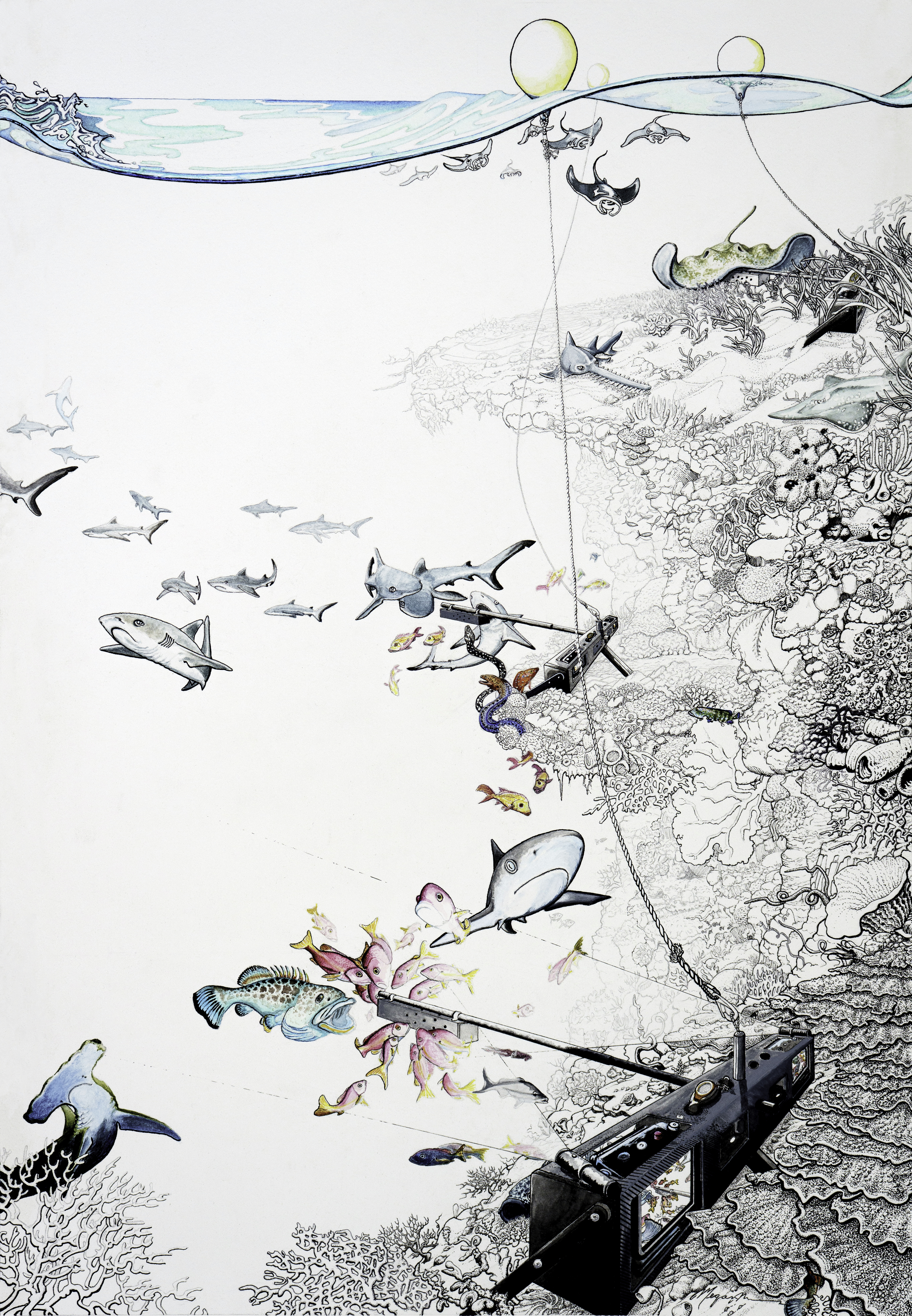
The method provides standardized measurements of fish diversity, relative abundance (MaxN), and body size across depths and habitats not accessible through other survey techniques, making it essential for comprehensive ecosystem assessment.
Method Overview
Seabed BRUVS employ stereo-camera systems with standardized bait to attract and record fish, operating as autonomous underwater observatories. This approach provides relative abundance estimates and precise length measurements for all observed taxa
Features
- Habitat versatility: Effective from shallow mangroves to deep reefs (5-70+ m)
- Substrate adaptability: Functions on sand, mud, rubble, coral, and rocky bottoms
- Current tolerance: Operates in calm lagoons to high-flow reef passes
- Passive sampling: Eliminates diver-induced behavioral bias
- Stereo cameras: Precise length measurements via calibrated camera separation
- Standardized bait: Consistent attraction stimulus across deployments
- Extended observation: Captures species with different response times to bait attraction
Key metric
The fundamental measurement unit in BRUVS surveys is MaxN (Maximum Number): the highest count of individuals of a given species observed simultaneously in a single video frame during the entire deployment. MaxN provides a conservative, standardized abundance index that accounts for individual fish moving in and out of the camera’s field of view.
- Eliminates double-counting of the same individuals
- Provides consistent abundance estimates across different deployment conditions
- Enables robust comparisons between sites, regions, and time periods
- Remains conservative when fish behavior varies
Field Implementation
Equipment
The system consists of a robust carbon fiber frame housing a stereo camera configuration with standardized bait attraction.
Frame Structure
The BRUVS frame provides a stable foundation for varied conditions:
- Camera bar: 80 cm carbon fiber bar housing stereo cameras at optimal separation
- Bait arm: 1 m horizontal carbon fiber pole extending from camera bar to position attractant within camera view
- Stabilization: Three carbon fiber weighted legs (2 kg per leg, 6 kg total) creating low center of gravity for secure positioning
- Surface connection: Marker buoy connected via 30-100 m line with scope adjusted for deployment depth
Camera System
The stereo camera configuration enables precise fish identification and measurement:
- Cameras: Two GoPro Hero 9+ in waterproof housings
- Stereo separation: 80 cm distance, 8° convergence angle toward bait
- Recording settings: 1080p at 25-30 fps for optimal stereo analysis
- Duration: Minimum 60 minutes continuous recording
- Synchronization: Time-synchronized for stereo-photogrammetric measurements
Bait Protocol
Standardized bait ensures consistent fish attraction across deployments:
- Quantity: 1 kg crushed oily fish per deployment
- Species: Sardines, tuna, mackerel, or locally available oily fish
- Preparation: Fresh bait crushed on deployment day for maximum scent dispersal
- Container: Perforated PVC canister allowing scent release while containing bait
- Positioning: Suspended 1 m horizontally from camera bar within optimal camera field of view
Lighting System
Depth-dependent lighting ensures adequate video quality for species identification:
- Shallow deployments (≤30 m): Natural light sufficient; no artificial lighting used
- Deep deployments (>30 m): Two 2600 lumen LED lights mounted on camera bar
- Light positioning: Angled to illuminate bait area without creating backscatter
- Battery management: Fresh batteries for each deployment cycle
Operations Schedule
BRUVS deployments are conducted using small boats with autonomous operations independent of the main research vessel:
Daily Workflow:
- Morning (7 AM - 12 PM): Primary deployments (1-2 three-rig sets)
- Afternoon (1-5 PM): Secondary deployments OR data processing and equipment maintenance
- Evening: Data backup, equipment preparation, and next-day planning
Team Structure:
- Small boat crew: 2-3 person team including boat operator and BRUVS specialists
- Set duration: 4-5 hours including deployment, 60-minute soak time, and recovery
- Communication: Regular check-ins with main vessel within radio/satellite communication range
Site Selection
BRUVS deployment sites are strategically selected to maximize habitat coverage while ensuring successful deployments:
Habitat Extension Approach:
- Complement diver surveys: Access environments beyond SCUBA limits
- Depth extension: Survey deeper reef slopes (>20 m) inaccessible to divers
- Habitat diversity: Sample seagrass beds, channels, sandy flats, and deep coral formations
- Geographic coverage: Expand total survey area, particularly for large islands or atolls
Critical Deployment Factors: Substrate slope is the most critical factor determining deployment success
- Optimal slope: Mild or steep but with ledges or stable substrate
- Assessment method: Depth sounder and direct visual reconnaissance when possible
- Risk indicators: Steep dropoffs, strong down-slope currents
- Backup planning: Alternative sites identified for each planned deployment
Deployment Procedure
Pre-Deployment Preparation
Equipment Setup (expedition start):
- Assemble three complete BRUVS rigs with carbon fiber frames, legs, and bait arms
- Prepare surface lines and buoys for each rig
- Synchronize camera date/time settings across all units
- Configure video settings: 1080p, 25-30 fps for stereo analysis
Daily Preparation:
- Install fresh batteries and empty SD cards in all cameras
- Clean camera lenses and housings thoroughly
- Attach lights to rigs if deploying >30m
- Ensure deployment lines have enough scope (1.5-2x target depth)
- Prepare fresh bait in perforated canisters
Equipment Loading:
- Boat box: GPS, depth sounder, deployment logbook, tools and spares
- Bait bucket: Freshly crushed bait into canisters
- BRUVS systems: Three complete rigs prepared for deployment
- Deployment gear: Lines, surface buoys, stereo calibration board (doodle board)
- Recovery equipment: Electric winch, marine battery, tools
Deployment Sequence
Site Assessment:
- Evaluate depth, current, and slope conditions
- Relocate and search for backup locations is needed
System Preparation:
- Connect rig to deployment line and surface buoy
- Attach fresh bait canister and verify even distribution of bait
- Power on cameras and verify recording status
- Synchronize cameras using board
Stereo Synchronization:
- Record deployment information: date, station ID, rig number
- Present calibration board clearly to both cameras as soon as cameras being recording
- Clap hands three times to synchronize cameras
Deployment Execution:
- Position boat appropriately for deployment
- Lower rig steadily to seabed maintaining orientation
- Monitor descent to ensure optimal landing position
- Record GPS coordinates and confirm deployment depth
- Frame orientation: Stable positioning with camera bar level
- Field of view: Bottom third captures substrate, upper two-thirds records water column
- Bait visibility: Attractant clearly visible and centered in camera field
Final Documentation:
- Mark precise deployment waypoint
- Record deployment time for 60-minute soak period
- Note current direction and intensity
- Assess surface buoy position and drift
Recovery Operations
After the 60-minute soak period, systematic recovery maintains data quality and equipment condition:
Approach:
- Approach recovery site cautiously to minimize fish disturbance or line entanglement
- Retrieve surface buoy and floating line
- Position boat directly over deployment and connect surface line to electric winch system
Retrieval:
- Use winch assistance for steady, controlled retrieval
- Monitor rig orientation during ascent
- Coordinate winch operation with boat positioning
Equipment management:
- Turn off cameras and LED lights
- Discard used bait and rinse container
- Swap cameras and batteries for next deployment cycle
- Secure frame and equipment for transit between sites
Return to Main Vessel
Upon completion of all deployments, systematic data handling and equipment maintenance ensure operational continuity and data integrity.
Equipment Care and Reset
- Immediate rinse: Thoroughly rinse all equipment with fresh water to prevent salt corrosion
- Winch system and battery connections
- BRUVS frames and attachment points
- Bait containers and deployment lines
- Camera handling: Carefully remove cameras and SD cards from all systems
- Transit preparation: Secure all equipment for vessel movement and weather protection
Data Transfer Protocol
- Primary transfer: Copy video files to hard drives using standardized structure:
- Left camera:
sbruv/deployments/[station_id]-L/ - Right camera:
sbruv/rdeployments[station_id]-R/ - Example:
sbruv/deployments/FJI-2025-sbruv-001-L/
- Left camera:
- Verification: Confirm successful file transfer by checking file sizes and playback
- Backup: Create secondary copy on portable drive
- Card clearing: Format SD cards only after verifying both primary and backup copies
- Metadata entry: Complete deployment records in digital fieldbooks immediately
Video Quality Assessment and Highlights
Conduct preliminary video review to assess deployment success and extract notable footage:
- Quality evaluation:
- Rate each deployment using 5-point scale (Excellent to Failed)
- Note equipment issues or deployment problems
- Highlight extraction:
- Scan footage for significant observations
- Extract 10-60 second clips of notable species, behaviors, or interactions
- Save to standardized highlights folder:
sbruv/highlights/ - Use naming convention:
[station_id]_[depth]m_[description].mp4 - Examples:
PLW_2023_sbruv_001_45m_grey_reef_shark.mp4PLW_2023_sbruv_003_25m_grouper_feeding.mp4
Next-Day Preparation
Prepare equipment and materials for continued operations:
- Power management: Place all batteries on overnight charging
- Bait preparation: Transfer frozen bait to thaw for next day’s operations
- Planning review: Confirm next day’s deployment sites and logistics
End-of-Expedition Procedures
Comprehensive end-of-expedition protocols ensure data preservation and equipment readiness for future operations.
Data Verification and Archival:
- Complete backup verification: Ensure all video files exist in multiple secure locations
- Fieldbook completion: Finalize all deployment metadata and quality assessments
- Highlight compilation: Create expedition highlight folder and reel for scientific and outreach use
Equipment Maintenance and Storage:
Prepare all BRUVS components for storage and future expeditions:
- Deep cleaning: Thorough freshwater rinse, lubrication, and inspection of all components
- Inventory update: Verify equipment conditions and note replacement needs
- Storage preparation: Properly pack and protect equipment for transport and storage
Data Workflow
Field Data Entry
Field data are recorded during deployment and recovery operations, then transferred to standardized Excel fieldbooks the same day to preserve accuracy. The ISO3_YEAR_sbruvs_fieldbook.xlsx serves as the primary repository for all deployment metadata.
- Readme: Expedition details, data collection protocols, and quality standards
- Deployments: Complete deployment records including environmental conditions and equipment status
Comprehensive metadata collection ensures data quality and enables ecological interpretation:
Spatial and Temporal Data:
- GPS coordinates (WGS84 decimal degrees)
- Deployment and recovery times
- Actual bottom depth
- Site name and regional hierarchy
Equipment Status:
- Rid and camera IDs
- Bait type
Video Quality Assessment: Each deployment receives a standardized quality rating:
Habitat Classification
All deployments are classified using standardized vocabularies for ecological analysis:
Primary Habitat Types
fore_reef— Seaward-facing outer slope of coral reef; typically steep and wave-exposed
reef_flat— Horizontal shallow zone at or near the reef crest; often exposed at low tide
back_reef— Sheltered zone just landward of the crest, with coral and rubble patches
lagoon— Protected interior waters behind reef crest; may include sand, seagrass, or patch reefs
patch_reef— Isolated coral outcrop within lagoon or sand plain; detached from main reef structure
channel_pass— Natural channel through reef with strong tidal flow and scoured bottom
pinnacle— Steep-sided, isolated coral or rocky structure rising from deeper water
rocky_reef— Non-coral reef formed from exposed rock, often supporting reef biota
sand_flat— Open sandy areas with minimal relief or structure
seagrass— Area dominated by seagrass cover, typically low relief and soft bottom
mangrove— Subtidal or shallow zone adjacent to mangrove roots, often muddy
estuary— Brackish coastal habitat where freshwater mixes with seawater
kelp_forest— Dense macroalgal canopy habitat (temperate or subtropical)
bank— Submerged, flat-topped offshore reef or rocky platform
Bottom_Type
rock— Solid bedrock, boulders, or consolidated hard substrate
hard_coral— Framework-forming stony corals (live or dead); includes massive, branching, and plate forms
soft_coral— Flexible non-skeletal cnidarians (e.g., gorgonians, sea fans, Xeniids)
rubble— Loose coral fragments, shell hash, and broken reef material
gravel— Loose rock fragments, pebbles, or cobble (non-biogenic)
sand— Sandy sediments, including coarse or fine grains
mud— Fine-grained, silty or muddy sediments
mixed— No single bottom type dominates (>75%); heterogeneous seafloor
Video Analysis
Video footage undergoes systematic analysis by our collaborating partners at the University of Western Australia (UWA) and the University of the South Pacific (Fiji) using EventMeasure software. All video is processed up to a 60-minute cutoff following standard protocols to identify each individual animal to the lowest possible taxonomic resolution, record the maximum number of each taxa observed in a single video frame (MaxN), and generate length estimates based on stereo-photogrammetric measurements of fork length.

Video-based identification presents unique opportunities and challenges compared to diver-based surveys:
- Repeated observation: Fish can be observed multiple times throughout deployment
- Detailed examination: Pause, replay, and zoom capabilities enable careful species examination
- Collaborative identification: Multiple taxonomic experts can review challenging identifications
- Permanent record: Video provides lasting evidence for taxonomic verification
Annotation protocol
Species Coverage
BRUVS surveys specifically target and excel at documenting predatory fish assemblages:
Sharks and Rays (Elasmobranchs)
- All shark species: reef sharks, pelagic visitors, deep-water species
- Rays and skates: stingrays, eagle rays, manta rays
- Excellent detection due to strong bait response and distinctive morphology
Large Predatory Teleosts
- Groupers (Epinephelidae): critical reef predators, strong bait attraction
- Snappers (Lutjanidae): important commercial species, reliable BRUVS targets
- Jacks and Trevallies (Carangidae): mobile predators, well-documented by BRUVS
Medium-sized Predators and Mesopredators
- Emperors (Lethrinidae): important in Indo-Pacific reef systems
- Wrasses (Labridae): larger species attracted to bait
- Triggerfishes (Balistidae): territorial species common around BRUVS
Commercial Species
- Barracuda (Sphyraenidae): attracted to bait and fish activity
- Surgeonfish (Acanthuridae): larger species occasionally recorded
- Parrotfish (Scaridae): opportunistic visitors to bait
Small Reef Fish
- Various families recorded opportunistically
- Generally undersampled compared to diver surveys
- Useful for community completeness
Invertebrates
- Large crustaceans: lobsters, large crabs
- Cephalopods: octopus, squid occasionally recorded
Processing Pipeline
Raw fieldbook data and video annotations are integrated and processed through standardized R scripts that validate data, calculate metrics, and generate analysis-ready datasets.
1. Data Integration and QA/QC
File Consolidation: - Merge deployment metadata with video analysis results - Standardize taxonomic names using reference database - Validate spatial and temporal data consistency
Quality Control Checks: - Review video quality ratings and exclude failed deployments (rating < 3) - Flag deployments with incomplete metadata - Validate MaxN calculations for internal consistency - Check length measurements against known species ranges
2. Taxonomic Standardization
PS Database Integration:
- Map taxa to accepted scientific names via
taxonomy.fish - Assign trophic groups and functional classifications
- Add length-weight relationships for biomass calculations
- Flag new records or range extensions for verification
3. Ecological Metric Calculation
Community Structure Metrics:
- Species richness: Total number of taxa per deployment
- Shannon diversity: Account for both richness and evenness
- Simpson diversity: Emphasize dominant species
- Functional diversity: Based on trophic and ecological groups
Abundance and Biomass:
- MaxN summaries: Species-specific abundance indices by deployment
- Biomass estimates: Length-based calculations using allometric relationships
- Trophic structure: Proportional abundance/biomass by functional group
- Size spectra: Community size distributions and mean body sizes
Conservation Metrics:
- Shark abundance: Critical ecosystem health indicator
- IUCN threat status: Proportion of threatened species
- Commercial species: Abundance of fishery target species
- Apex predator ratio: Proportion of top predators in community
4. Database Integration
Processed data are formatted for ingestion into the Pristine Seas Science Database:
- sbruv.stations: Station-level metadata and summary statistics
- sbruv.observations: Individual-level records with taxonomic classification and MaxN
- sbruv.maxN_by_taxa: Station-level metadata and summary statistics
These standardized outputs enable consistent analysis across expeditions while preserving connections to original observations.
Exploratory Data Analysis
Comprehensive EDA examines BRUVS data through multiple ecological lenses, focusing on predator communities and ecosystem health indicators.
Community Analysis
Diversity Patterns:
- Species accumulation curves to assess sampling adequacy
- Alpha diversity comparisons across habitats and protection levels
- Beta diversity analysis to understand community turnover
- Indicator species analysis for habitat association
Assembly Structure:
- Multivariate analyses (NMDS, cluster analysis) of species assemblages
- Functional group composition across environmental gradients
- Size spectrum analysis to detect fishing impacts
Ecological Assessment
Predator Community Health:
- Shark abundance as ecosystem health indicator
- Top predator biomass ratios and trophic pyramid structure
- Mean body size trends indicating fishing pressure
- Apex predator presence/absence patterns
Conservation Insights:
- Threatened species occurrence and abundance
- Commercial species population status
- Comparison with reference values
- Identification of hotspots and critical habitats
Environmental Relationships:
- Depth-related community changes
- Habitat-specific assemblage patterns
- Current and exposure effects on community structure
- Distance-to-protection relationships
Cross-Method Integration
Complementary Survey Analysis:
- BRUVS vs. UVS fish community comparisons
- eDNA validation of species presence
- Benthic habitat relationships with fish assemblages
Ecosystem Connectivity: - Mobile predator movement patterns between sites - Nursery-adult habitat connectivity - Spillover effects from protected areas - Regional biogeographic patterns
Limitations
While seabed BRUVS provide valuable standardized data on predatory fish assemblages, several methodological limitations should be acknowledged when interpreting results.
Sampling Bias
Bait Attraction Variability: Fish responses to bait vary significantly among species and individuals. Some species show strong positive attraction, others exhibit active avoidance, and territorial species may exclude other fish from the immediate area around the bait.
Size and Behavioral Bias: Larger, more aggressive predators may dominate bait areas, potentially excluding smaller individuals or species. This can lead to underestimation of juvenile abundance and species that are less competitive around bait.
Temporal Coverage: Standard 60-minute deployments provide only a brief snapshot of fish community activity. Species with different temporal activity patterns (dawn/dusk activity, tidal influences) may be missed or underrepresented.
Technical Limitations
Environmental Dependency: Successful deployments require suitable sea conditions and stable substrate. Steep slopes, strong currents, poor visibility, or equipment failure can result in partial or complete data loss.
Detection Limitations: MaxN provides minimum abundance estimates as individuals moving in and out of the camera’s field of view may not be detected simultaneously. Video quality affects species identification accuracy, particularly for smaller or more cryptic species.
Methodological Considerations
Observer Effect Elimination vs. Limited Behavior: While BRUVS eliminate diver effects, they may not capture natural feeding behaviors, territorial interactions, or species that don’t respond to bait stimulus.
Community Representation: BRUVS excel at documenting predatory fish but systematically underrepresent small-bodied species, herbivores, and planktivores compared to visual surveys.
Standardization Challenges: Variations in bait type, quantity, freshness, and local availability may affect comparability between deployments and regions.
Mitigation Strategies
Complementary Methods: We integrate BRUVS with UVS, eDNA, and other techniques to provide comprehensive ecosystem assessment that accounts for each method’s strengths and biases.
Standardized Protocols: Protocols for equipment preparation, deployment procedures, and data analysis ensure valid comparisons across sites and time periods.
Quality Control: Multiple deployment replication, video quality assessment, and expert taxonomic review address technical and analytical sources of error.
Appropriate Interpretation: Results are interpreted within the context of method-specific limitations, focusing on questions that BRUVS are well-suited to address: predator abundance, community structure, and fishing impacts.
References
Cappo M, Harvey E, Malcolm H, Speare P (2003) Potential of video techniques to monitor diversity, abundance and size of fish in studies of Marine Protected Areas. In: Beumer JP, Grant A, Smith DC (eds) Aquatic Protected Areas-what works best and how do we know? World Aquaculture Society, Baton Rouge, Louisiana, pp 455-464
Cappo M, Speare P, De’ath G (2004) Comparison of baited remote underwater video stations (BRUVS) and prawn (shrimp) trawls for assessments of fish biodiversity in inter-reefal areas of the Great Barrier Reef Marine Park. Journal of Experimental Marine Biology and Ecology 302(2):123-152
Harvey ES, Shortis MR (1995) A system for stereo-video measurement of sub-tidal organisms. Marine Technology Society Journal 29(4):10-22
Harvey ES, Fletcher D, Shortis MR, Kendrick GA (2004) A comparison of underwater visual distance estimates made by scuba divers and a stereo-video system: implications for underwater visual census of reef fish abundance. Marine and Freshwater Research 55(6):573-580
Langlois T, Goetze J, Bond T, Monk J, Abesamis RA, Asher J, Barrett N, Bernard ATF, Bouchet PJ, Birt MJ, Cappo M, Currey-Randall LM, Driessen D, Fairclough DV,-Fullwood LAF, Gibbons BA, Gill DA, Harasti D, Heupel MR, Hicks J, Holmes TH, Huveneers C, Ierodiaconou D, Jordan A, Knott NA, Lindfield S, Malcolm HA, McLean D, Meekan M, Miller D, Mitchell PJ, Newman SJ, Radford B, Rolim FA, Saunders BJ, Stowar M, Smith ANH, Travers MJ, Wakefield CB, Whitmarsh SK, Williams J, Harvey ES (2020) A field and video annotation guide for baited remote underwater stereo‐video surveys of demersal fish assemblages. Methods in Ecology and Evolution 11(11):1401-1409
McLean DL, Harvey ES, Fairclough DV, Newman SJ (2010) Large decline in the abundance of a targeted tropical lethrinid in areas open and closed to fishing. Marine Ecology Progress Series 418:189-199
Murphy HM, Jenkins GP (2010) Observational methods used in marine spatial monitoring of fishes and associated habitats: a review. Marine and Freshwater Research 61(2):236-252
Santana-Garcon J, Newman SJ, Langlois TJ, Harvey ES (2014) Effects of a spatial closure on highly mobile fish species: an assessment using pelagic stereo-BRUVs. Journal of Experimental Marine Biology and Ecology 460:153-161
Watson DL, Harvey ES, Anderson MJ, Kendrick GA (2005) A comparison of temperate reef fish assemblages recorded by three underwater stereo‐video techniques. Marine Biology 148(2):415-425
Whitmarsh SK, Fairweather PG, Huveneers C (2017) What is Big BRUVver up to? Methods and uses of baited underwater video. Reviews in Fish Biology and Fisheries 27(1):53-73